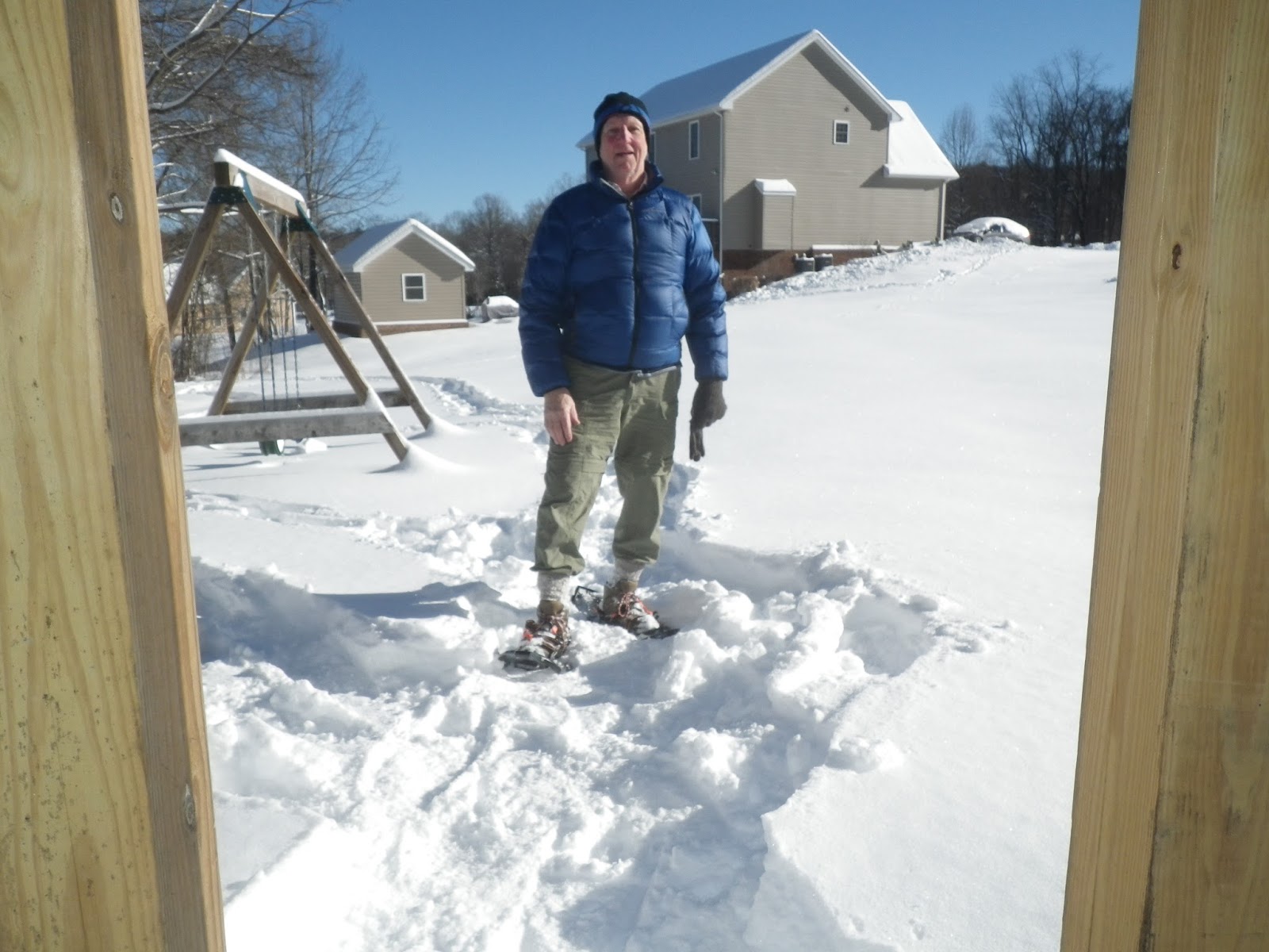
Snowshoeing can be fun and be a way to get outside and enjoy hiking in the winter time. Snowshoes can make backpacking a safer way to walk in deep snow. I have backpacked in a deep twenty inch snow without snowshoes and I was exhausted after three miles on the Appalachian Trail. It snowed this past week with a twelve inch snow and I have been practicing walking in my new snowshoes.
Equipment
A good pair of high gators should be worn to help keep the snow and debris from getting into your boots.
A pair of trekking poles. Trekking poles will help you balance when you walk.
A pair of high top hiking boots will keep your socks dry and a pair of smart wool socks will keep your feet from getting cold.
The snowshoe should be lightweight and made of a strong metal/plastic design. The snowshoes should not be too big and fit snug around your boot. The frame should be made of an aluminum tubing. Crampons on the bottom of the shoe should be made of a strong steel. All front straps should be a fiber composition whereas the heel strap should be a flexible material. Most snowshoes are designed for a left or a right foot. I bought
Atlas snowshoes and have walked around my home to get used to hiking in deep snow.
Snowshoe use
When wearing snowshoes you should try to keep your weight centrally located above the shoe, especially when walking down hill. Try not to lean back when going downhill, leaning back will create a snowboarding effect and you will lose your traction. Try to keep the space between each foot wider than your normal walk. This will keep you from walking on the other shoe. You will have to raise your foot a little higher than you normally walk. Remember that it will be harder to make sharp turns and you will have to plan each turn ahead of the time to turn. Most snowshoes have quick release straps so you can easily slip your foot out of the shoe if you step in a deep hole or crevasse. Snowshoes are designed to aid you in walking in deep snow. Walking in deep snow can be exhausting and cause you to over heat and possibly get hypothermia and possibly die.
The Bushbuddy wood burning stove is a double-walled heat-shielded backpacking stove. There are several other stoves that look very similar and perform in the same way as this stove. There is even a do-it-yourself version that you can make at home. The concept is simple in that there are holes at the bottom of the cylinder to let in needed air for combustion and the heat and gasses excape out the top heating the container on top. A wind shield is needed to contain the burning action and to keep an even flow of warm air up the can. I have found that the average time to boil a liter of water is about ten minutes. The stove weighs around five ounces or 141.7 grams. With the addition of a fuel container when wood is wet you may burn an esbit tablet to heat your water.
Bushbuddy Wood Burning Stove
Esbit solid fuel container
Four Dog Woodburning Stove
The Four Dog woodburning stove is a very small one
pieced self contained stove. It has four metal wedges
welded onto the top of the rim to hold a small pot of
less than one liter. The supply air enters from the side
holes crosses over a twisted pie shaped disk to the pot.
The pot is made of titanium metal. The time to boil
a pot of water is approximately eight to ten minutes.
The Appalachian Trail going to the top of Mt. Katahdin in Baxter State Park is called Hunt Trail. The weather on the trail to the top of Mt. Katahdin may quickly change from a warm sunny, to a cool, cloudy, and windy day. The day we hiked up the mountain it was cool with winds up to forty miles per hour. The day before it had been raining with zero visibility. This day it was clear with a low lying haze that reached across the low lands. At times we could see many small lakes scattered across the plain. As I hiked I tired, and I wished I could be fishing in one of those lakes instead of climbing over boulders. As you watch the video notice the smaller evergreen trees as they give rise to their smaller shrub like-cousins. The boulders are coated with algae and some lichen making it harder to use as hand holds. We used the trekking poles as an extra boost to pull each other up the rocks. Listen to the wind as it blows across the camera microphone. A low flying airplane passed across our field of view. In some spots we allowed several hikers to squeeze by us on the thin ledges, trying not to loose our grip. Many of the granite boulders are very loose, and we had to take special care not to fall off the ledges. At times the white trail blaze markers seem to go straight up the fifteen-foot boulders. Along one section of the trail there are monkey bars anchored into the boulders.
The famous trail challenge is to ascend the boulders by way of the monkey bars. The monkey bars are two one inch diameter bars mounted in granite boulders. The idea is to climb the boulders stepping on the two monkey bars, one of which was broken and only a stub, like a ladder up the ninety-degree slope. This is an impossible feat, except if you are like me and have bad knees that will not bend to allow climbing the ladder. A woman hiker volunteered to pull me up by my pack from above, while another hiker pushed me up from below. I managed to clear the monkey bars for the next part of the trail.
A good pair of hiking boots was a necessity to climb the boulders. Our cheap box store trekking poles managed to last the entire climb without breaking. Leather gloves are a necessity climbing over the rough surfaces of the weathered boulders. Without gloves your hands become worn raw from the small-pocketed depressions in the boulders. The Appalachian Trail white blazes mark almost impossible routes up the ten to twelve foot boulders. It was great to have someone to help me up the fractured rocks. One slip, and over the side of the mountain you could go.
The winds blowing up to forty miles an hour made the climb more of a challenge. The trail was very narrow, and passing hikers made the trail even more difficult to navigate. Closer to the top I could see for miles on a clear day.
Algae and other microscopic life live in the pocked spaces of the rocks, make climbing a little more difficult for gaining hand holds. People of all lands come to Maine to hike Mt. Katahdin and we met many who could not speak English. The winds got stronger the higher we hiked, and often at times the only way was straight up the boulder shelf.
Very close to the top of the mountain is a flat area called the Table Lands. This is the point to which Henry David Thoreau climbed the mountain. The trail is roped off in an effort to protect the fragile, flattened ecosystem of the table lands. After about a half mile the trail ascends the mountain to the top. A sign at the top announces that you have achieved the goal. A drink of Gatorade was a refreshing gift after the long climb.
I felt like one tired, older guy making it to the top with not much energy to spare. We took a different trail down the mountain. That trail called the Abol Trail had just been rerouted and was much steeper and harder to climb due to the many rock slides that had occurred previously. We were so glad that we had been required by park rangers to take head lamps on the trail because we returned back to camp well after night fall. It was a hard climb, but I was so glad to finish the hike. Not many people my age hike, and even fewer ever get a chance to go to the top of Maine's highest mountain, Mt. Katahdin. I would not have been able to make it without the help of my son-in-law pulling me up the boulders. I am thankful that the Lord gave me the strength to be able to complete the hike with the help of my caring son-in-law.
I considered the hike a challenge because of my desire to hike the ending point of the Appalachian Trail, despite the tough terrain.
James 1:2-3 "Consider it pure joy, my brothers, whenever you face trails of many kinds, because you know that the testing of your faith develops perseverance."
Hiking from Katahdin River Falls to the Tree Line (Part 2).
Hike Planning and Preparation
Our hiking equipment consisted of a day backpack, hat, two base-layer shirts, two mid-layer shirts, two mid-weight hiking pants, a light weight rain coat, a low to mid-cut pair of hiking boots, two pair of wool socks, synthetic underwear, two one-liter water bottles, a two liter inside pack water bladder, gloves, snacks, neckerchief, suntan lotion, two trekking poles, tent, sleeping bag, sleeping mat, mini-stove, fuel, spoon, matches, dehydrated food, and water. We had to purchase the stove fuel and trekking poles in Bangor, Maine. The poles would not fit in our luggage, and the fuel is not allowed on the plane. It was easy to find the fuel, but we had a hard time finding four trekking poles. After several hours we managed to find three red-colored inexpensive poles, and one blue good quality pole which we left for the motel maid. My son-in-law also carried a folding chair to sit and to relax in on top of the mountain.
The Hike
The Appalachian Trail, leading up to Baxter Peak--the top of Mount Katahdin from the Katahdin Stream Campground--is called the Hunt Trail. The trail takes eight to ten hours round-trip depending on ability. The trail is considered very strenuous. The beginning mile and a half is not very steep. Once the tree line is reached, the trail is made up of all large boulders. As you hike up the trail let your senses take over and take the time to drink in the beauty of God's creation. Notice that the path is no longer covered with two to three inches of sand but is mixed with larger rocks with an occasional series of granite rock steps. There are many downed smaller trees mainly consisting of hardwoods. The rocks are very irregular and fractured, making it easy to twist an ankle or knee. The smaller trees form a dense fortress that is a natural barrier to keep the hiker on the trail. There is no cell phone reception.
The rocks became more plentiful the higher we climbed up the mountain. The rocks are covered with moss and lichen, a natural process of decay. Notice you do not see many larger trees because this area has been logged years ago before it became a state park.
The trail crosses the Katahdin Stream by a wobbly wooden bridge with no railings. The stream is fed by mountain springs and snow melt from the top. It is very cold, and you can only keep your feet in the water a very few minutes without freezing them. The trail has a diverse population of moose, black bear, and white-tailed deer. The wooded areas of the park support bobcats, fishers, martens, weasels, chipmunks, red squirrels, snowshoe hares, coyotes, lemmings, and red foxes. The most common birds are warblers, thrushes, flycatchers, owls, hawks, eagles, and ducks.
Larger and larger boulders replace the smaller basketball sized rocks. The trail is marked by the familiar white blaze marking the path of the Appalachian Trail. The higher we hiked the fewer large trees were found, and the white blazes were painted on rocks rather than the trees. The trail continues to follow Katahdin Stream as we ascended the mountain. There is no electricity, running water, or paved roads in Baxter Park. The "Forever Wild" philosophy is maintained all along the trail.
Just slightly over a mile on the trail and off to the left is Katahdin Stream falls. It is exciting to see large amounts of water cascading down the mountain side. The Mount Katahdin was formed by granite intrusion weathered to the outside surface. The plants and animals are typical of those found in northern New England. Beside the igneous rock there are outcrops of sedimentary rocks. The sedimentary rock weather to form beds of sand along the trail.
Small to medium-sized boulders cover the path along the trail as if cut from larger boulders and hand-placed. The trees on both sides of the trail are much smaller and have changed in diversity from hardwoods to evergreen species.
The trail gets wider the higher in altitude you climb, and almost all of the larger trees are gone. When we hiked, the air temperature rose from forty to fifty degrees in three miles. My camera lens fogged from the air moisture of the rain the day before and the temperature change. The lower elevations give rise to hardwood tree species of red maple, sugar maple, yellow birch, paper birch, American beech, white ash, black ash, big tooth aspen, and quaking aspen.
The closer to the top the larger the boulders and warmer the temperatures are. The higher elevations give rise to balsam fir, tamarack, white spruce, black spruce, red pine, white pine, northern white-cedar, and eastern hemlock.
Thousands of years ago the Lauren Tide Ice sheet melted northward in New England, creating large boulder slides. The next 1,000 years time period brought about the emergence of the existing growth forest. Trekking poles were used to help lift me from one big boulder to the next. I lost all cartilage in both knees about 20 years ago and cannot bend my knees more than half way. I can still hike with the aid of trekking poles and a strong son-in-law. Next months blog will cover part three of the hike from the tree-line to the top of Mount Katahdin.
Isaiah 55:12, - "For ye shall go out with joy, and be led forth with peace: the mountains and the hills shall break forth before you into singing, and all the trees of the field shall clap their hands."
Mount Katahdin: The Northern Terminus of The Appalachian Trail (Part I)
The Appalachian Trail is approximately 2,100 miles long along the eastern portion of the United States. Depending on which direction one starts, the trail either begins or ends in the state of Maine. At an elevation of 5,268 feet above sea level, Baxter Peak on Mount Katahdin is the highest mountain point in Maine. The climb to the top is 4,200 feet in 5 miles with most of the trail above the treeline. The mountain is one of the main attractions in Baxter State Park, a private/public park in Maine.
Elevation Map of the Trail
Mount Katahdin is a massive gray granite monolith, formed from a central Maine forest surrounded by many lakes. The native Americans called the mountain "Kette-Adene," the greatest mountain, and worshiped it. Thousands of years ago the continental glacier planed off the top of the mountain leaving the flat table lands rising to the south, now called the "table lands." The vegetation on top of the mountain was formed by glaciers, and above the 3,000 feet elevation the vegetation is like that in the Canadian tundra, in Greenland, and northern Labrador. In 1846 Henry David Thoreau ascended to the table lands where he found deep thick clouds and other objects that obscured his view. The weather on top can change at a moment's notice, and high winds may reach 50 miles per hour, therefore, hiking to the top is discouraged. The 5.2 mile trip to the top takes approximately 5 hours, and the return trip will take about the same time. Every hiker must register at the beginning of the hike and sign in at the finish. Everyone must carry a flash light in case they return after dark.
My Adventure
My son-in-law and I started our adventure in late August with a flight to Bangor, Maine by way of Philadelphia, Pennsylvania. We rented a car and drove 72 miles to Millinocket, Maine, followed another 8 miles to Baxter State Park and again an 8 mile drive to Katahdin Stream Camp Grounds. We rented a lean-to, a four person three-sided building, for two nights. The first day was rainy with 50 plus mile an hour winds on top of Katahdin Mountain. We opted to postpone our hike to the top and instead hiked the Appalachian Trail around the camp. The second day the rain stopped, and the winds dropped to 40 miles per hour. The weather on top of the mountain is very unpredictable, and one can never be sure if the mountain can be climbed on any particular day. I had talked with many people who had been very disappointed that they could not complete their hike as planned due to extreme winds, poor visibility and slippery conditions. The day we hiked the mountain it was 75 degrees, and sunny with winds around 30 to 40 MPH. The story of our hike will be divided into three blogs. The first blog will cover the hike from the camp site to the treeline. The second from the treeline to the Table Lands, and the third from the table lands to the top of the mountain.
Katahdin Stream Campsite to the Treeline
The Appalachian Trail led past our lean-to, and we thought that was a sign this trip was going to be an easy hike. We said our prayers and asked God to help us with a safe and secure hike. The path was sandy and several feet wide. After signing the journal at the trail head we turned our head lamps on and began the hike at 6:30 AM. In order to hike this trail one must sign in and carry a head lamp. The park rangers advised us that the round trip hike may take from 10 to 12 hours. We planned to finish the hike around 4 PM; followed by a drive back to Bangor and the flight back home. Often times plans do not go as expected. The trail was covered with several inches of fine sand. Great forces of wind, flowing water, freezing and thawing, and rocks sliding over one another cause erosion to occur and sand to be formed. Walking was easy and good to the knees, but that did not last long. The sandy trail gave rise to cobble-sized rock and then to small boulders. The trees were small in diameter and consisted mostly of aspen and birch. It appeared that most of this area had been logged probably before the land was donated as a park. We saw evidence of this driving from Bangor to Millinocket when we passed a huge lumber mill the size of a small city. The hike was approximately 5.2 miles to the top and another 5.2 miles in return. There are less steep trails to the top on the back side of Katahdin Mountain, but they are not part of the Appalachian Trail. The trail climbs 5,000 feet in elevation in 5 miles. The tree line ends after traveling 1 mile, and at this point there are no water and bathroom facilities. The park advises all hikers to carry 3 to 4 liters of water. There is a large area near the top called the Table Lands that is an environmentally protected area, and cannot walk out of the 1 foot wide trail range. The following video documents the beginning of our hike. It is almost dark, and you can hear the Katahdin Stream as it flows beside the trail for the first mile of the hike.
Psalm 17:5 (NIV) - My steps have held to your paths; my feet have not stumbled.
Friday, February 17, 2017
Hiking and Backpacking In The Golden Years
As I age my outlook on life changes from personal achievements and accomplishments to just enjoying everyday life. Every morning I wake up and thank God that Iam able see another day and experience the new events He has in store for me. I feel very grateful for each day on earth to experience family fun and to enjoy God's creation. Camping, hiking, and backpacking are some simple ways to see God's natural plan. I have learned never to take life for granted and always keep my eyes on Jesus. I have been hiking and backpacking for the past thirty years and have enjoyed many unique experiences. There have been some great encounters with other hikers and wild animals along the trails. I realize that I am among some of the most privileged people on earth. The majority of men my age are not physically or financially able to hike. I grew up in a log cabin on fifteen acres of hardwood forest, my home was at one time used during the Civil War as a hospital . We had no running water, no electricity, and no central heating. My dad installed electricity and modernized the exterior with siding. A spring supplied us with fresh water, and a pot bellied stove heated the cabin. The outdoors was my play ground. I never lost that love for the outdoors. It is such a great feeling to go backpacking and relive those experiences. Backpacking consists of carrying shelter, food, water, clothes, ground cover, and sleeping materials all in your pack. A typical backpack weight may range from twenty to sixty pounds. It is exciting to know that when I hike I am carrying everything I need to survive in the outdoors. It has become an art to select the lightest and best equipment as well the most comfortable clothes for all kinds of weather. Every backpacking adventure is different no matter how many times I hike the same trail. God always shows me something I had not seen before. In my next series of blogs I will share my experience hiking to the top of Mt. Katahdin, the northern terminus of the Appalachian Trail in Baxter Park.
What's next? In the next series of pod casts I will be discussing my hike to the top of Katahdin Mountain in Maine. Tech Notes: In future pod casts I will be reviewing equioment to take on a backpacking trip.