Saturday, March 23, 2013

High Bridge State Park
Farmville, Virginia


One of the newest state parks in Virginia highlights a trail that contains a long high bridge over the Appomattox River.  The trail is a non-motorized multi-use trail for hiking, biking, and horseback riding. Bicycling the trail is a good way to get in shape early in the season.


Description: The trail is approximately 4 feet wide and 31 miles long. It is constructed of packed fine crushed white limestone along an old railroad bed originally belonging to Norfolk Southern Railroad. Mountain, hybrid or road bikes can easily ride the trail. Since it is relatively level and generally flat it is easy for bicyclists of all ages to ride the trail. 


The highlight of the trail is the high bridge that crosses over the Appomattox River.


The bridge is 2,400 feet long and approximately 10 feet wide (steel tower) built in 1853 by Southside Railroad.  The bridge is 160 feet to 125 feet above the Appomattox River.  The wooden deck bridge sides or railings are high and constructed so that you do not have to worry about falling over the edge into the river. There are observation platforms with park benches equally spaced along the bridge.  The bridge trail maintains a historic 6 % grade mimicking the original railroad elevation that makes it easy for bicycling or running.


Bicycle rider riding across the High Bridge


Observation deck with bicycles

The bridge is the longest recreational bridge in Virginia, and one of the longest in the United States.


For your comfort the trail is lined with picnic tables and toilets.  


Bench constructed part of an Eagle Scout project


Toilet facility


Drinking water is not available along the trail. Also along the trail are the original railroad concrete mile markers, and you also can see the remains of telegraph poles erected in the 1900's. 


The trail begins at Pamplin, VA and ends 31 miles just short of Burkesville, VA. Park rangers and local police monitor the trail daily. A small fee is charged at the beginning of the trail.

Park History: The trail was constructed along an old railroad bed that ran from Lynchburg, Virginia, to Petersburg, Virginia. The High Bridge trail now starts along the old railroad train tracks bed in the city of Pamplin, passing over and under roadways and through the cities of Prospect, Farmville, Rice, and ending north of Burkeville. Pamplin was once the largest clay pipe factory in the world. 


The trail crosses over roadways


Roadway crossingwith warning sign for motorists


Cities will often post a sign for the trail.


The High Bridge was originally made of wood with 21 brick piers, a pedestrian walkway, and wagon bridge alongside. The trail and bridge were very important during the Civil War. 


Historic marker at the beginning of the bridge


Old signs of the original pedestrian walkway


Remains of the old wagon crossing


Two very decisive battles were fought here in April, 1865 and lead to General Lee's final days of the war. On April 6 and 7, 1865, one of the final battles occurred that helped to end Lee's campaign 2 days latter in Appomattox. Troops of the armies of the North and South tried to burn the bridge down, but the bridge prevailed, and it was later donated to Virginia by the Norfolk Southern Railroad in the year 2006. The last train traveled over the bridge on October 26, 2004. The park is now part of the Virginia State Park system, a part of the Virginia Department of Conservation and Recreation.

Flora & Fauna:  A turkey was seen along the trail as well as a green snake. 


Green Snake

Many wildflowers were also observed along the edges of the trail. In June you may see the early low bush blueberry, blue ridge blueberry, winter grape, pigeon grape, suckling clover, kidney leaf rosin weed, marsh bristle grass and the bristly fox tail in bloom. While standing on the bridge in the spring you can hear what sounds like hundreds of spring peeper frogs echoing below.


Nearby town: Farmville is one of the largest towns that the trail passes through about halfway into the ride. It has lots of little eating places for you to stop for lunch or to freshen up before traveling further.


Old town Farmville sign


The High Bridge is located due east from the town of Farmville


      Local diner in Farmville for a lunch break before the High Bridge

JOHN 7:38 - Whoever believes in me, as the scriptures has said, streams of living water will flow from within him.

Thank you for viewing my podcast, and please leave a comment.


Sunday, September 2, 2012


Grand Canyon Rim-2-Rim Hike

This Blog Contains Videos of My Backpacking Trip Down the North Rim of the Grand Canyon Via the North Kiabab Trail to the Top of the South Rim Hiking Up the Bright Angel Trail.

To remember my backpacking experience I decided to use a Hero GoPro video camera to record the event.


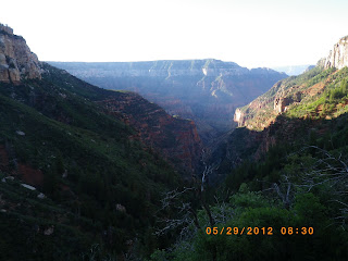
The trail leading to the bottom of the Grand Canyon is called the North Kiabab Trail. It begins at an elevation of 8,000 feet above sea level. The trail switches back and forth among evergreens and cottonwood trees till it reaches the Phantom Ranch and the Colorado River. Three inches of dust coats the trail for the entire 14 miles to the ranch.  The dust cushions the impact to the knees making it a pleasant hike.  The north rim trail is shaded much of the hike.                


Only 15,000 people are granted permits out of 70,000 applicants to hike and camp in the Grant Canyon  each year in the months of May and September. The three of us were granted the permit to hike and the permit had to be displayed attached to the pack at all times.  


The trail up the south rim of the Grand Canyon is called the Bright Angel Trail.  It is maintained with cross logs and rock wanes to help the mule trains navigated the trail safely. The temperature at the bottom of the Grand Canyon the day before was 120 degrees and 102 degrees that night. I hiked out from the campsite the next morning at 4 AM to try to get through the hottest part of the trail before the sun reached its highest point around 1 PM.


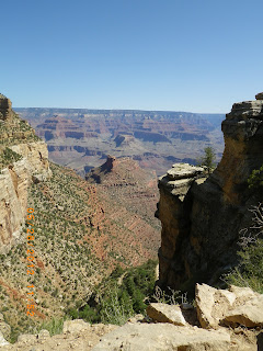
Some of the best views of the canyon can be seen from the south rim trail. Many tourist hike to the Indian Garden Campground and back for a 10 mile hike.

And make straight paths for your feet, lest that which is lame be turned out of the way;  but let it rather be healed.  Hebrews 12:13 

Monday, August 6, 2012

     
Backpacking Rim-2-Rim Grand Canyon Arizona
                              Part 2
Many people ask me why I would ever consider backpacking the Grand Canyon, and I answer by saying, "Because it is one of the many great wonders of the world that was created by God." We often get so bogged down with the every day routine of work and family life that we take for granted the great things in nature that God has created for our enjoyment. It is exciting to walk some of the same trails that our  pioneers and first explorers walked many years before. I also feel a special kinship with them when I put on a backpack with all of the necessities of life such as food ,water, shelter, clothing, and hike in much the same way as they did in the beginning. The excitement of knowing that if you hike into the canyon you must hike out because there is no other way out unless you are seriously injured. You are on your own. A helicopter port is located at every campground and at selected sites for the "bumblebee" copter ride out for the injured.  I also enjoy meeting and talking to fellow hikers along the trail. They come from all over the world to hike the Canyon. No matter what language they speak we all have the beauty of the canyon as a common bond.

Phantom Ranch

I ended Part 1 staying at the Bright Angel Campground near the Phantom Ranch. My two hiking companions and I stayed two days at the campground. The ranch is the only overnight lodging below the rim. It has eleven rustic cabins and two dormitories along the banks of Bright Angel Creek surrounded by cottonwood trees. A canteen serves home-cooked meals; showers and flush toilets add a touch of luxury.  The ranch acts as an overnight station for rafters and mule riders. Reservations for the ranch are accepted 13 months in advance and sell out within a few hours on the first day on January. I applied for a camping permit for the three of us for a end of May hike. Approximately 70 thousand people apply to overnight hike for the months of May and September,  and only 15 thousand are accepted--most of which are overnight hikers coming down from the South Rim. Not many people hike from Rim-2-Rim. 

                                                       Bright Angel Campground
                                     (photo was taken by Arnold Leonard)
   
There is a T-shaped metal pole on the left side of this picture, and it is designed for the hiker to hang pack on the top to keep animals from getting into it. The biggest problem are the ground squirrels. Ground squirrels look like tree squirrels but they live in holes in the ground and can jump high for long distances. They often jump up to the hanging packs and raid anything that is not in a metal container. I saw one squirrel jump onto a hanging pack, disappearing under the flap only to reappear within minutes with a chocolate cookie in its mouth. Most of our food was keep safe from animals in large military metal ammunition boxes provided by the campground. Each campground had national park rangers who provided care and guidance and evening programs to campers and lodge members. The campsite was great but the flush toilets were not working, and we had to carry water from the nearby stream to flush it after each use. The ranger explained that the rocks do a lot of shifting and tend to cause a break in the pipes supplying water to the ranch and campground. Sometimes when a water line runs along the trail a waterline breakage can wash out part of the trail. One such wash out did occur, and it washed out over 50 feet of trail. Fortunately we were already past that point in the trail. Some hikers were less fortunate and had to back track back to the beginning the trail.

                                           Ground Squirrel looking for a hand out.

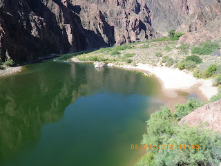
We hiked around the Phantom Ranch onto the Clear Creek Trail. This trail climbs high above the Phantom Ranch at several advantage point overlooking the Colorado River. Views of the South Kiabab and Bright Angel Trails can clearly be seen from this point. I sat on a large rock and watched as the mule trains carrying up to twenty riders slowly made their way down the South Rim. I could also watch the whitewater rafters float down the river. The Colorado River is a pretty green with very little silt in it because of the two dams on the river above and below the canyon.

                                 
                                                  Wooden Deck Suspension Bridge


 If you look closely you can see the trail that carries mule riders down the South Rim.


                                                              Crossing Bridge

There are two suspension bridges one metal and one wooden. They cross the Colorado River from the South Rim.
                                                            Colorado River

At the right edge of the river you may be able to see some rafters who have stopped to visit the Phantom  Ranch (2,400 feet above sea level). The trip began on top of the North Rim at 8,250 feet above sea level.

                                                                      Tunnel

All mule riders coming to the Phantom Ranch from the South Rim via the South Kiabab Trail must come through a short tunnel in the rocks before crossing to the Colorado River. 

                                                  Mule Train mule fitted for riding 
                                               (photo taken by Hezekiah Goodson)

Can you imaging riding a mule and having to squeeze through this tunnel?  Most mule riders are given an hour long presentation by the mule team leader on what to expect and how to ride a mule. I overheard a mule team leader telling one young teenager that the mule she was riding liked to hug the outside of the trail next to the drop off. I know that probably did wonders for her confidence in riding mules on a skinnny trails.

 
The temperature in the Bottom of the canyon is 120 degrees
(photo was taken by Arnold Leonard)

The temperature at the bottom of the canyon is usually 20 to 25 degrees warmer than at the rim. At night it was 101 degrees with no air circulation and was a very dry heat. We were encouraged to sit in the Bright Angel Creek during the day to keep cool. As soon as we got out of the water we  dried very quickly.

                                                                  Indian Ruins

Native American tribes of the Hopi, Havasupi, Navajo, and Southern Paiute inhabited the Grand Canyon around A.D. 1300. There are many ruins from their existence near the Phantom Ranch along the Colorado River.

                                                                The Box

In order to get to the next campsite-- Indian Garden-- we had to hike through "The Box." The Box is a narrow canyon with high rock walls on both sides. Temperatures in the canyon can reach  dangerously high levels in the Box if it is not passed before noon. Many hikers start well before sunrise to be sure to get through the canyon on time. It was strange seeing groups of hikers with their headlamps on bouncing past our campground like little fireflies at night. We left at around 5:30 AM and had no trouble getting through it. If you look very closely you can see the trail at the bottom of the canyon. 

                                                               Sunrise shadows

I loved hiking in the morning, watching the sunrise cast shadows of one canyon wall onto another.

                                                                South canyon trail

The Bright Angel Trail leading to Indian Garden Campground was very easy to walk on because it consisted of a loosely packed weathered sedimentary soil. At no time did we have to rock scramble or walk on loose boulders. The trail was easy for mules to walk upon. The mule train guides were very proud to say that they have never lost a tourist or riding mule in the history of mule trips.

                                                        Indian Garden campground

Indian Garden Campground was the last overnight stop before we reached the South Rim--the end of our backpacking trip. The campground was an oasis of green in the desert. Native Americans settled here because there was an ample supply of water and available food to eat. The Grand Canyon is a desert with hot and dry conditions without the sand-like environment you see in traditional deserts on television. We always had access to water along the trail and didn't have to worry about dehydration.


The next morning at 4:00 equiped with headlamp on I left to get a jump start before the sun came up. I was well into the last 5 miles before the sun came up. The last 5 miles was loaded with people of all nationalities hiking down from the South Rim. Many people like to hike several miles down the rim just to get an idea of what it is like to hike the Bright Angel Trail and to be able to say they hiked the Grand Canyon.


                                        Hiking through one of the tunnels along the trail.
                                              (Photo taken by Arnold Leonard)


Along this section of the trail there are warning signs to help keep hikers safe.


At the end of the trail at the top of the South Rim.


A happy smiling finished backpacker!

Isaiah 40:4-- Every valley shall be exalted, and every mountain and hill shall be made low: and the crooked shall be made straight, and the rough places plain.

The Following Photos Taken by Arnold Leonard


Saturday, July 14, 2012

Grand Canyon Rim-2-Rim Backpacking Arizona
                            Part 1

Preparation

It takes a lot of preparation and prayer to plan for a backpacking hike across the Grand Canyon. There are two times a year that the Grand Canyon National Park service will permit campers to hike the Grand Canyon rim to rim. Most of the camping facilities are open in the spring and the fall. May and September are the permitable months of the year. Two friends and I decided to try for the May hiking window. We could choose any days from mid-May through the first week in June. We decided on the four days from May 23 to May 26 but left it open for any four days in the permitable season. I applied on the first day of January for the May hike.  We finally were granted a permit to camp May 26 through May 29. There are no permits required for day hikes. You may make any day hikes you wish, but you must complete the hike in one day. Many people trail run the entire 25 miles from rim to rim in one day, and a few even run the trail rim to rim to rim in one day. We could have hiked the trail in three days, but we stayed an extra day at Phantom Ranch to do a few day hikes. One of our other hiking friends advised us to do it that way. 

The Plan Summary

We flew from the east coast to Phoenix, stayed the night, rented a car, and drove to the Grand Canyon the next day. We then drove to the south rim and spent the night.  The next day we took the shuttle to   the north rim and spent the night at the North Rim Campground. The next morning we got an early start at  5 AM. We hiked to the Cottonwood Campground, approximately 7 miles, and stayed the night. The next morning we began again at 5 AM and hiked 7 miles to Bright Angel Campground,. We spent an extra day at the Bright Angel Campground. The fourth day we hike 5 miles to  Indian Garden Campground an oasis half way up to the south rim. The last morning I left camp at 4 AM because the previous day's temperature was 119 degrees, and I wanted to reach the south rim before it got too hot.  This was a 5 mile hike. That day we showered, changed into travel clothes, and returned the rental car to fly back home.

Detailed Trip


The flight to Phoenix was uneventful except the metal zippers in my convertible hiking pants set off the metal detectors, and I had to be searched. I checked my suitcase at the ticket counter. My theory was to put my empty pack into my suitcase and load everything else on top of it. That way if the suitcase was searched they could put everything back into the suitcase without much disruption. The plan worked great.  When I got to the south rim campground I repacked the backpack and left the suitcase in the rental car. The shuttle the next day cost $85 per person and took about four hours to reach the north rim campground. 


                                                        South Rim Mather Campground


                                                        North Rim Shuttle


The north rim shuttle carried around nine passengers.  Of the nine passengers only the three of us were hiking rim-2-rim. The other passengers were running the trail in one day. They planned to start at 4 AM the next day and  finish at 4 PM the same day.


Some people take the mule ride to the bottom of the canyon. The riding mules are kept apart from the pack mules by cutting their tails differently. The riding mules have a staggered cut tail and are trained for a much different ride than the pack mules.


After spending the night at the North Rim Campground my two hiking friends and I started at 5 AM the rim-2-rim hike on the North Kaibab Trail, which is around 8,000 feet .


The trail was about two to three feet wide and about two inches of deep dust. It was easy hiking and the dust cushioned my knees. Photo taken by an unnamed hiking companion.


We traveled through the Supai Rock Tunnel and saw the Roaring Springs gushing from the side of the canyon high above on the wall of rock.


The first night we stayed at the Cottonwood Campground about 7 miles down the trail. We were amused half the day by lots of 3 to 5 inch long lizards puffing out their colorful necks and doing more push ups than Rocky could ever think about doing. Much of the trail from this point on is paralleled by Bright Angel Creek. 


The next day after a short hike we took a detour to Ribbon Falls about 3,720 feet in elevation. This day's hike was 7 miles long, ending at the Bright Angel Campground near the Phantom Ranch at 2,490 feet in elevation. 


Before we could reach the Phantom Ranch and Bright Angel Campground we had to go through The Box. The Box is part of the Bright Angel Canyon--a very hot part of the trail, and we had to get through it before the hottest part of the day from noon to sundown.


This a picture of the pack mules at the Phantom Ranch. All supplies had to be packed into the ranch and Bright Angel Campground. The ranch canteen had the best ice cold lemonade and served a great beef stew. This photo was take by Hezekiah Goodson, Jr.


This is Bright Angel Campground. A T-shaped pole in the background was a futile effort to stop ground squirrels from getting into our packs. Ammunition boxes were provided at each camp site to protect our food from wild animals. Photo was taken by an unnamed hiking companion.

The next part of the journey will be on my next blog Part 2.