Sunday, April 9, 2017

Katahdin to the Treeline


Hiking from Katahdin River Falls to the Tree Line (Part 2).

Hike Planning and Preparation 

Our hiking equipment consisted of a day backpack, hat,  two base-layer shirts, two mid-layer shirts, two mid-weight hiking pants, a light weight rain coat, a low to mid-cut pair of hiking boots, two pair of wool socks, synthetic underwear, two one-liter water bottles, a two liter inside pack water bladder, gloves,  snacks, neckerchief, suntan lotion, two trekking poles, tent, sleeping bag, sleeping mat, mini-stove, fuel, spoon, matches, dehydrated food, and water.  We had to purchase the stove fuel and trekking poles in Bangor, Maine.  The poles would not fit in our luggage, and the fuel is not allowed on the plane.  It was easy to find the fuel, but we had a hard time finding four trekking poles.  After several hours we managed to find  three red-colored inexpensive poles, and one blue good quality pole which we left for the motel maid.  My son-in-law also carried a folding chair to sit and to relax in on top of the mountain.

The Hike


The Appalachian Trail, leading up to Baxter Peak--the top of Mount Katahdin from the Katahdin Stream Campground--is called the Hunt Trail.  The trail takes eight to ten hours round-trip depending on ability.  The trail is considered very strenuous.  The beginning mile and a half is not very steep.   Once the tree line is reached, the trail is made up of all large boulders.  As you hike up the trail let your senses take over and take the time to drink in the beauty of God's creation.  Notice that the path is no longer covered with two to three inches of sand but is mixed with larger rocks with an occasional series of granite rock steps.  There are many downed smaller trees mainly consisting of hardwoods.  The rocks are very irregular and fractured, making it easy to twist an ankle or knee.  The smaller trees form a dense fortress that is a natural barrier to keep the hiker on the trail.  There is no cell phone reception.


The rocks became more plentiful the higher we climbed up the mountain.  The rocks are covered with moss and lichen, a natural process of decay.  Notice you do not see many larger trees because this area has been logged years ago before it became a state park.


The trail crosses the Katahdin Stream by a wobbly wooden bridge with no railings.  The stream is fed by mountain springs and snow melt from the top.  It is very cold, and you can only keep your feet in the water a very few minutes without freezing them.
The trail has a diverse population of moose, black bear, and white-tailed deer.  The wooded areas of the park support bobcats, fishers, martens, weasels, chipmunks, red squirrels, snowshoe hares, coyotes, lemmings, and red foxes.  The most common birds are warblers, thrushes, flycatchers, owls, hawks, eagles, and ducks.


Larger and larger boulders replace the smaller basketball sized rocks.  The trail is marked by the familiar white blaze marking the path of the Appalachian Trail.  The higher we hiked the fewer large trees were found, and the white blazes were painted on rocks rather than the trees.  The trail continues to follow Katahdin Stream as we ascended the mountain.
There is no electricity, running water, or paved roads in Baxter Park.  The "Forever Wild" philosophy is maintained all along the trail.


Just slightly over a mile on the trail and off to the left is Katahdin Stream falls.  It is exciting to see large amounts of water cascading down the mountain side.  The Mount Katahdin was formed by granite intrusion weathered to the outside surface.  The plants and animals are typical of those found in northern New England.   Beside the igneous rock there are outcrops of sedimentary rocks.  The sedimentary rock weather to form beds of sand along the trail.


Small to medium-sized boulders cover the path along the trail as if cut from larger boulders and hand-placed.  The trees on both sides of the trail are much smaller and have changed in diversity from hardwoods to evergreen species.


The trail gets wider the higher in altitude you climb, and almost all of the larger trees are gone.  When we hiked, the air temperature rose from forty to fifty degrees in three miles.  My camera lens fogged from the air moisture of the rain the day before and the temperature change.  The lower elevations give rise to hardwood tree species of red maple, sugar maple, yellow birch, paper birch, American beech, white ash, black ash, big tooth aspen, and quaking aspen.


The closer to the top the larger the boulders and warmer the temperatures are.  The higher elevations give rise to balsam fir, tamarack, white spruce, black spruce, red pine, white pine, northern white-cedar, and eastern hemlock.


Thousands of years ago the Lauren Tide Ice sheet melted northward in New England, creating large boulder slides.  The next 1,000 years time period brought about the emergence of the existing growth forest.
Trekking poles were used to help lift me from one big boulder to the next.  I lost all cartilage in both knees about 20 years ago and cannot bend my knees more than half way.  I can still hike with the aid of trekking poles and a strong son-in-law.
Next months blog will cover part three of the hike from the tree-line to the top of Mount Katahdin.

Isaiah 55:12, - "For ye shall go out with joy, and be led forth with peace: the mountains and the hills shall break forth before you into singing, and all the trees of the field shall clap their hands."


Wednesday, March 1, 2017

The Beginning of Hike


Mount Katahdin: The Northern Terminus of The           Appalachian Trail (Part I)


The Appalachian Trail is approximately  2,100 miles long along the eastern portion of the United States.  Depending on which direction one starts, the trail either begins or ends in the state of Maine. At an elevation of 5,268 feet above sea level, Baxter Peak on Mount Katahdin is the highest mountain point in Maine.  The climb to the top is 4,200 feet in 5 miles with most of the trail above the treeline. The mountain is one of the main attractions in Baxter State Park, a private/public park in Maine.


                     Elevation Map of the Trail


Mount Katahdin is a massive gray granite monolith, formed from a central Maine forest surrounded by many lakes. The native Americans called the mountain "Kette-Adene," the greatest mountain, and worshiped it.  Thousands of years ago the continental glacier planed off the top of the mountain leaving the flat table lands rising to the south, now called the "table lands." The vegetation on top of the mountain was formed by glaciers, and above the 3,000 feet elevation the vegetation is like that in the Canadian tundra, in Greenland, and northern Labrador.

In 1846 Henry David Thoreau ascended to the table lands where he found deep thick clouds and other objects that obscured his view. The weather on top can change at a moment's notice, and high winds may reach 50 miles per hour, therefore, hiking to the top is discouraged.  The 5.2 mile trip to the top takes approximately 5 hours, and the return trip will take about the same time. Every hiker must register at the beginning of the hike and sign in at the finish.  Everyone must carry a flash light in case they return after dark.  

My Adventure

My son-in-law and I started our adventure in late August with a flight to Bangor, Maine by way of Philadelphia, Pennsylvania.  We rented a car and drove 72 miles to Millinocket, Maine,  followed another 8 miles to Baxter State Park and again an 8 mile drive to Katahdin Stream Camp Grounds.   We rented a lean-to, a four person three-sided building, for two nights.

The first day was rainy with 50 plus mile an hour winds on top of Katahdin Mountain.  We opted to postpone our hike to the top and instead hiked the Appalachian Trail around the camp.   The second day the rain stopped, and the winds dropped to 40 miles per hour.  The weather on top of the mountain is very unpredictable, and one can never be sure if the mountain can be climbed on any particular day.  I had talked with many people who had been very disappointed that they could not complete their hike as planned due to extreme winds, poor visibility and slippery conditions.  The day we hiked the mountain it was 75 degrees, and sunny with winds around 30 to 40 MPH.   The story of our hike will be divided into three blogs. The first blog will cover the hike from the camp site to the treeline.   The second from the treeline to the Table Lands, and the third from the table lands to the top of the mountain.


Katahdin Stream Campsite to the Treeline

The Appalachian Trail led past our lean-to, and we thought that was a sign this trip was going to be an easy hike.  We said our prayers and asked God to help us with a safe and secure hike.  The path was sandy and several feet wide. After signing the journal at the trail head we turned our head lamps on and began the hike at 6:30 AM.  In order to hike this trail one must sign in and carry a head lamp.  The park rangers advised us that the round trip hike may take from 10 to 12 hours.   We planned to finish the hike around 4 PM; followed by a drive back to Bangor and the flight back home. Often times plans do not go as expected.

The trail was covered with several inches of fine sand.   Great forces of wind, flowing water, freezing and thawing, and rocks sliding over one another cause erosion to occur and sand to be formed.  Walking was easy and good to the knees, but that did not last long. The sandy trail gave rise to cobble-sized rock and then to small boulders. The trees were small in diameter and consisted mostly of aspen and birch. It appeared that most of this area had been logged probably before the land was donated as a park.  We saw evidence of this driving from Ban
gor to Millinocket when we passed a huge lumber mill the size of a small city.  The hike was approximately 5.2 miles to the top and another 5.2 miles in return.  There are less steep trails to the top on the back side of Katahdin Mountain, but they are not part of the Appalachian Trail.   The trail climbs 5,000 feet in elevation in 5 miles.  The tree line ends after traveling 1 mile, and at this point there are no water and bathroom facilities.  The park advises all hikers to carry 3 to 4 liters of water. There is a large area near the top called the Table Lands that is an environmentally protected area, and cannot walk out of the 1 foot wide trail range.

The following video documents the beginning of our hike.  It is almost dark, and you can hear the Katahdin Stream as it flows beside the trail for the first mile of the hike.


Psalm 17:5 (NIV) - My steps have held to your paths;
                           my feet have not stumbled.

Friday, February 17, 2017

Hiking and Backpacking In The Golden Years

As I age my outlook on life changes from personal achievements and accomplishments to just enjoying everyday life.  Every morning I wake up and thank God that Iam able see another day and experience the new events  He has in store for me.  I feel very grateful for each day on earth to experience family fun and to enjoy God's creation.   Camping, hiking, and backpacking are some simple ways to see God's natural plan.  I have learned never to take life for granted and always keep my eyes on Jesus.

I have been hiking and backpacking for the past thirty years and have enjoyed many unique experiences.   There have been some great encounters with other hikers and wild animals along the trails.  I realize that I am among some of the most privileged people on earth.  The majority of men my age are not physically or financially able to hike.

I grew up in a log cabin on fifteen acres of hardwood forest, my home was at one time used during the Civil War as a hospital .  We had no running water, no electricity, and no central heating.  My dad installed electricity and modernized the exterior with siding.  A spring supplied us with fresh water, and a pot bellied stove heated the cabin.  The outdoors was my play ground.  I never lost that love for the outdoors.

 It is such a great feeling to go backpacking and relive those experiences.  Backpacking consists of carrying shelter, food, water, clothes, ground cover, and sleeping materials all in your pack.  A typical backpack weight may range from twenty to sixty pounds.  It is exciting to know that when I hike I am carrying everything I need to survive in the outdoors. It has become an art to select the lightest and best equipment as well the most comfortable clothes for all kinds of weather.  Every backpacking adventure is different no matter how many times I hike the same trail. God always shows me something I had not seen before.

In my next series of blogs I will share my experience hiking to the top of Mt. Katahdin, the northern terminus of the Appalachian Trail in Baxter Park.


What's next?
In the next series of pod casts I will be discussing my hike to the top of Katahdin Mountain in Maine.

Tech Notes: In future pod casts I will be reviewing  equioment to take on a backpacking trip.


Saturday, December 12, 2015

Appalachian Trail (AT) in the Winter in Central             Virginia

     Several times a year a group of Christian friends from nearby churches go on a backpacking adventure.  A few of the men want to complete the Virginia portion of the AT,  while others like me just want to bask in the beauty of God's creation. The miracle of God's divine design in every plant and animal living along the trail makes me want to loudly sing with joy like Julie Andrews in the Sound of Music.  But if I want to see any wildlife at all I try to keep my singing to a whisper. 
     Our backpacking trip began on the AT just north of the Apple Orchard Falls Trail and ended crossing the James River, a distance of approximately fifteen miles.  At the beginning of the hike along Thunder Hill a German balloonist crashed his balloon while in an international race in 1928.   We camped at the halfway mark at Marble Springs, a spot where an old shelter  had once been located.  Our water supply was a spring located a few hundred yards down the mountain.   
     The first day we passed through portions of the 2,344 acre Thunder Ridge Wilderness.   Just before Marble Springs the trail passed through Petites Gap named after John Poteet a settler in 1740.   Between 1850 and 1875 the lower forested area was harvested and the wood used to generate charcoal for the production of pig iron.  Much of the rock in the area consists of hard, granite-like, igneous rocks.   Years of continued erosion has produced a form of very fertile soils as evidenced by the luxuriant trees and thickets of mountain laurels and rhododendrons.  From a distance along Arnold Valley you can see the Devil's Marble yard, an eight-acre field of fractured quartzite metamorphic rocks that contain fossil wormholes.  
     The second day we crossed through a gap known by locals as Archie's Notch named after Archibald "Bear" Tolley, a well known bear hunter.   Another area we crossed was Highcock Knob, named after a man who owned a cabin nearby and two roosters that would go high on an oak tree and that area became known as "High Cock Knob."   
     At the conclusion of the hike we crossed the James River.  The James River is estimated to be 160 million years old and the longest waterway in Virginia, flowing 450 miles from the Allegheny Mountains to the Chesapeake Bay.   The river is crossed by a 625 foot long foot bridge constructed in 2000 on piers from a 1881 railroad bridge.


An Appalachian Trail marker along the Blue ridge Parkway at mile post 76.3.


Along the trail there are many switch backs indicated by a double white blaze marker.


Coyotes have become very common along the trail and leave scat filled with rabbit and squirrel hair.


The night time temperatures in December are in the 20's, creating heavy frost along the trail in the morning.


In many areas the trail is marked with posted signs instead of white blazes to help preserve the natural feel of the surrounding wilderness.


The James River can be seen from the top of the ridge covered with a freezing fog.


James River Foot Bridge is 625 foot long.


The foot bridge was constructed on old train trestle pilings.

Isaiah 2:3  "And many people shall go and say, Come ye, and let us go up to the mountain of the Lord, to the house of the God of Jacob; and he will teach us of his ways, and we will walk in his paths; ..........."


Tuesday, December 1, 2015


Appalachian Trail Wild Flowers and Selected Plants 

There are many plants found on and around the Appalachian Trail. The following photos are a small representative of them.  Because of the ecology, the trail may be considered a deciduous tree forest. There are many insects and birds that aid in the production of plant species. For example, bees and other flying insects help pollinate  flowers and, many birds eat the plant seeds in one area and later "poop out" in another area.


This flower, known as Smooth Gerardia, Gerard laevigata, is found in dry woods among oak trees, usually from July to September.  It is a bright yellow funnel or bell shaped flower about one to one and a half inches long. It is called "false yellow foxglove" and it is fairly common in the southern mountains.


The Spring Beauty . Clayton Virginica, has white to pink flowers with deeper pink veins. These flowers are first to show up during the spring and only last for about three days. Deer and moose as well as chipmunks, mice, and people have found the roots to be quite delectable and nutritious.  When eaten raw the roots taste like radishes and when cooked taste like potatoes.


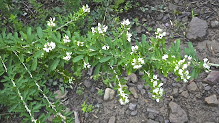
Chinese clover, Sericea lesoedeza, is a perennial legume.  It is herbaceous with a woody stem.   A small cluster of flowers is located on a branched stem, on the average it grows with a three feet tall stem surrounded by small leaflets.  It flowers from July to October and is used for erosion control and feed.


Although hardwoods predominate the trail one will also see evergreens of pines growing in the background.  The white pine, Pinus strobes, has needles for leaves clustered in bundles of five,  shaped like a "W."   It grows in dry, higher elevations and rocky ridges. 


The Virginia pine, Pinus virginiana, is found in large numbers in the upper Coastal Plain and hilly areas of Virginia and surrounding states.  The needles grow in bundles of two and form a "V." They vary from one and a half to three inches in length.


The sugar maple, Acer saccharin, is often called the sugar tree and is found in the cool slopes in the mountains.  It is usually a slow growing tree forming a dense crown for heavy shade.  The leaves are three to five inches across, pointed and with sparsely toothed lobes.   These leaves are responsible for the bright red colors in the fall.


Mountain laurel, Kalmia latifolia,is found in the wooded areas around rocky or sandy soils from New Brunswick to Ontario and south to Florida and Louisiana.  It has a very beautiful flower but is poisonous and should not be used for cooking.  It grows three to fifteen feet high.


Hair cap moss, Polatrichum commune, gets its name from hairs that cover a cap where each spore case is held.  It has a star shaped appearance because of the way the leaves are shaped on the stem.  It grows four to twenty centimeters tall.  The average life span is five years.  It lives in lightly shaded areas with moist acidic soil and sometimes in full sunlight.  It grows wild from granite outcropping to the coastal plain.  It is used by some people to make a tea to dissolve kidney and gall bladder stones.  It is also believed by some to be good for the hair as a rinse to straighten hair. In the past it has been woven to make baskets.


Wild geranium, Geranium maculatum, has lavender flowers with five petals (sepals) with deeply forked leaves.  It can be found in wood thickets and meadows.  It flowers April through June.


The fire pink, Silene virginica, has bright red long-stalked flowers in loose clusters at the top of a slender stem.  The flowers have five petals that bloom in April through June.  A common name is catch fly because of the sticky hairs that trap insects. 


The rue anemone, Anemonella thalictroides, flower has three leaves, each with three lobes, that form a whorl on the stem below the flower cluster of this six to eight inches plant.  The flowers are white to pinkish with five to ten petal-like sepals.  The flowers bloom from April through June.  It is found in open wooded areas. 


The large-flowered trillium, Trillium grandiflorum, grows eight inches to eighteen inches tall.  The color of the flowers ranges from white to deep pink.  It grows in rich foods and often in coves and on slopes.  The trillium goes through a long process to bloom.  The flower becomes pollinated and develops a berrylike fruit.  The seeds inside the fruit enlarge, and the fruit breaks open and fall to the ground on fertile soil.  The seeds are carried underground by ants where they spend two years, and then they break the surface and continue to grow for four more years developing leaves.  After a minimum of six years from the time the seeds touched the ground, a blossom will appear and the plant will continue to produce flowers for many seasons.  It blooms April through June.


White snakeroot, Eupatorium rugosum, has heart-shaped or triangular leaves and is very common in rich woodlands at high altitudes with snow-white flowers clustering August and September.  The plant has coarsely toothed-shaped leaves on a slender stem.  There have been some fatal cases of "milk-sickness" in man and cows that have been traced to the use of milk from cows that had eaten white snake.


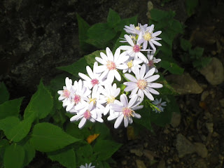
The small flowers  on the white aster, Aster vimineus, are August through October in dry to moist fields and meadows to shores.  It grows two to five feet tall.  The flower head is about a third inch wide and is arrayed in groups of fifteen to thirty.


Lady's thumb, Polygonum persicaria,  is made up of dense erect, oblong or cylindrical spikes of small pink or purplish flowers at the tops of simple stems.  The flower clusters are four mm long to two inches long.  There are no petals but the sepals are four to six and colored.  The fruit are seed like and glossy black.  It flowers in June through October alongside roads, damp clearings, and cultivated ground.


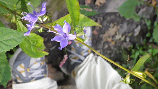
Tall bellflower, Campanula americana, has a stem one to four feet in length.  The one inch flower has five light blue petals in a star shaped pattern.  It flowers June through September.   It is found in moist woods and on open slopes off the Blue Ridge Parkway and in the Great Smoky Mountains National Park.


Crested dwarf iris, Iris cristata, was named by the Greeks for their goddess of the rainbow. It prefers wooded slopes and ravines.  The pale to deep purple flowers are divided into parts.  The three petals are narrow and arching, and the three petal-like sepals are broader, curved downward. It is streaked with purple and are crested with white to yellow ridges.   It blooms from April to May.


Pale jewel weed, Impatiens pallia, flowers are a yellow coloration and side-turned sepal spur divided into two parts.  Because of its fruit it is also called snapweed and touch-me-not.  The seeds mature inside a coiled capsule and when ripe explode out of the capsule when touched.  Some people believe the sap of this plant will ease poison ivy itch.  It is found in moist woods, gaps, and coves.  It blooms from June through September.


Rock tripe lichen, is found growing on the rocks throughout the trail. Lichen is a combination of an algae and a fungus.  The fungus aids in anchoring the algae to the rock and the algae helps provide nourishment for the fungus.  In a survival situation you can eat the lichen after a series of boiling and water changing.  It might be a little on the chewy side.


Bloodroot, Sanguinaria canadensis, is usually two to eight inches tall, with one leaf usually folded around the stem.  The majority of the plant is found underground, and that is why it is called bloodroot.  The plant may be poisonous if eaten.  It is a skin irritant to some people.


Sassafras, Sassafras albidium, is a small aromatic tree usually not over forty feet in height an a foot in diameter.  It is common in dry soils and is the first to repopulate abandoned fields.  The seeds are spread by birds.  There are three different leaves on the tree -- a three lobed, single lobed, and a dual lobed.  The wood was originally used for posts, rails, and boat-building.The oil from the bark and roots was used to flavor candles.


The mountain maple is really an ash tree but the leaves resemble a large maple leaf.  It was originally classified as a maple but later reclassified as an ash.  It is very unique because it has long longitudinal white stripes leading up the plant stem.  You may see this tree often along the trail. 


The galax, Galax aphylla, is ten to twenty-four inches tall with heart-shaped shiny leaves.  It is found June through July, but you have to be very observant to find it along the trail.   It may be found in open woods and rocky slopes.


The tulip poplar, Liriodendron tulipifera, is better known as the tulip tree or yellow poplar.  It has a yellowish flower as well as the heartwood of the tree.  It is one of the largest and most valuable hardwood trees.  It grows in deep moist soils usually along streams and the lower mountain coves. Trees may grow from sixty to one hundred feet tall and three to four feet in diameter.  Bees are known to make honey from their very large flowers.  The wood is cut into lumber and used for veneers and furniture.


Ferns like the Christmas fern, Polystichum acrostichoides, grow to a height of one to two feet and spread one to two feet.  They are non-flowering and grow in part shade to full sun.  The soils may have dry to medium water content.  The leaves are long green blades with many leaflets shaped like Santa's boots.  This is one of the only plants that tolerate rabbit, deer, drought, heavy shade, erosion, and shallow rocky soils.


Poison ivy, Toxicodendron radicals, leaves are all in groups of three on the stem or vine.  The leaves are often shiny and green, the vines are covered with hairs.  They bloom in May through June.  All parts of the plant are poisonous and touching causes severe, weeping rashes on people who are sensitive to the plant oils.  


Fringed polygala or gaywings, Polygala paucifolia, with three-quarter inch reddish or purple flower has a center tube and two tubes perpendicular to the center tube.  It blooms in April through June.  They thrive in woods with acid soils and small colonies up to elevations of 2,500 feet.  These flowers were once considered as members of the milk wort family and believed to be able to stimulate the increase of milk in cows, hence the scientific Greek name poly and gala or much milk. 


Jerusalem artichoke, Helianthus tuberosus, the toothed egg-shaped upper leaves are alternate and the lower leaves are opposite on the stem.  The flower is yellow and blooms in August thru October.  The plant does not come from Jerusalem and is not in the artichoke family.   The Native Americans and colonists ate the tuber of this plant, it sometimes can be found in supermarkets.


The red maple, Acer rubrum, is a medium sized tree--quick growing and relatively short--lived.  It is used as a shade tree but is inferior to other maple trees.  The bark is smooth and light to dark gray in color. The normally green leaves turn bright red in the fall.  The fruit consists of pairs of winged seeds about one half to one inch long.  The wood is a soft close--grained and rather weak light brown.  It is used to manufacture furniture, wooden ware, and for fuel.


Columbine, Aquilegia canadensis, reminded people of a flock of hovering birds and so it earned the Latin name columba or "dove."  The flowers long curved spurs resembled an eagle's talons or Aquilegia Latin for eagle.  Bees just nip the flower tip to drain the nectar out and hummingbirds love these flowers, as well.  It was believed that juice from a fresh flower was used to reduce a swollen liver from jaundice or to cure measles or small pox.  The plant may have a soothing effect on pain.  It blooms from April thru July.  The flower may be red or yellow.


Virginia spring beauty, Clayton virginica, has two long lanceolate leaves opposite each other on the stem.  The one--half inch five petal flowers are white with pink lines.  It blooms from March through May and is found in moist wooded areas.  The flowers only last three days.  Deer and moose browse on the tiny flowers, but humans and small animals like to eat the roots.  The roots taste like radishes when raw and like potatoes when cooked. 


Star chickweed, Stellaria puberal, is known for its white flower but is valued by birds,animals, and humans.  Birds find its seeds to be quite delectable so it is also known as birdseed.  Grazing animals are drawn to it because the plant is a source of copper.  European markets sell it because it is considered a very tender edible green and is added to many salads.  It is also high in vitamins A and C--helpful treatment for scurvy.  It has also been known as a poultice for abscesses and boils.  According to folklore the sun will be shining bright if the blossoms are spread out to their fullest.  If the flower begins to close that means rain is coming.

PSALMS 103:15--As for man, his days are as grass: as a flower of the field, so he flourisheth.







Friday, November 6, 2015

Appalachian Trail Hike Over Blood Mountain

I think often of individuals who are not physically able to hike but wish they could take one step on the Appalachian Trail and feel great about it.  That's why I do not let any type of weather keep me from doing it.  Rain, snow, sleet, hail do not stop me from putting one foot in front of the other.  Thunder and lightening are the only factors that will make me stay home.
 I usually hike in waterproof trail shoes, baseball hat, and rain coat.  On rare occasion I will hike in gators, rain pants, and maybe an umbrella.  As strange as it might seem, it is not hard to carry an umbrella and walk with a trekking pole at the same time.  I may look funny, but I stay very dry.
Years ago my wife bought me a Golite umbrella, but I never had the nerve to hike with it for fear of being called  a wimp.  However, I have used it during snow storms and heavy  rainfalls.  It feels really good to keep the rain from stinging my face and  the cold water from running down my neck and back.
While hiking up Blood Mountain I passed seven thru hikers who all liked the idea of the umbrella.  All seven looked as if there was not a dry spot on their body. I stopped and chatted with all of them about what might be next after they finished the trail.  The hikers had one night left on their quest to finish the 2,100+ miles of the Appalachian Trail (AT).
I am a section hiker and am not physically able to hike more than 100 miles at any one time.  As part of a southern vacation my wife agreed to help me hike a 10.7 mile section of the Appalachian Trail from Woody Gap to Neel Gap.  She dropped me off at the trail head and then picked me up that evening at the end of the trail.  Many times she has been the shuttle guide for drop off and pick up.  Most men my age are not interested in spending time hiking or backpacking any trail.  The picture below was taken at the beginning of my hike in the Chattahoochee National Forest Neel Gap by way of Blood Mountain in pouring rain.  Blood Mountain is the highest peak on the Appalachian Trail in Georgia at 4,458 feet.  There are several theories for the name Blood Mountain. One theory is that it is the spot where the Cherokee and Creek Indian tribes had a big battle for territorial land rights and thousands of indians died. Another theory is that there was a mass murder of colonists in this area by indians, and the last theory is that it is named Blood Mountain because of the red colored lichen on the rocks.


The umbrella, gators, rain jacket and waterproof shoes kept me dry for most of the hike.


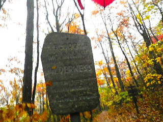
An old sign announcing the beginning of the Blood Mountain wilderness where the highest mountain on the Appalachian Trail in Georgia is found.


The trail is clearly marked with the white blaze.  It is hard to get lost on the trail because if you miss a white blaze you can turn around, and you will more than likely see a blaze making the other hiking direction.


There are trail directional signs located in areas where other trails cross the AT. The trail sign indicated that my hike was 11.7 miles long.


After thousands of hikers have hiked the AT,  the trail has become like an elongated bath tub.  All the rain and snow that falls stays on the trail and all attempts to make the water run off the trail by using water bars is almost useless.  The water was two to three inches deep for most of the hike. My waterproof shoes did a great job keeping my feet dry.


The trail was posted with bear warning signs due to all of the bear sightings at the camp areas.  The most bear activity was in the spring and bear canisters were advised for campers/hikers.


A stream restoration project was being performed at the base of Blood Mountain on a small creek about two feet wide and caution was encouraged by hikers.


It was October and the maple leaves were in full color.


There are very few four-walled shelters on the AT and Blood Mountain has one of them.  It was built in 1934 by the Civilian Conservation Corp.  I looked inside and it was dry but very damp with concrete floors.


The privy was an above ground structure called a composting toilet.  There was no privacy for all viewers could see you sitting from the waist up.


At the top there were shear rock slabs covered with wet leaves. That made it very dangerous to walk.  Two of the last three miles of the hike were on extremely slippery rock slabs and steps.


The trail leading down the north slope was shaped like a elongated rock bath tub.  The pounding rain and driving winds made it very difficult to walk down the steep slope.


Toward the bottom of the hike the trail was composed largely of steps made out of layered rock.  The down step was about twice the drop of a normal stair step in a house.  The impact to the knees was very stressful.  With every step I could hear mentally my couch potato friends say, "That is why we do not hike."

At the bottom of Blood Mountain at Neel Gap is a large backpacking store and hostel called the Mountain Center, the only place on the AT where you actually pass through a man-made rock structure.   You can restock any of your needs as well as have a bed, towel,  and hot shower all for seventeen dollars.


Isaiah 40:4 - Every valley shall be exalted, and every mountain and hill be made low: and the crooked shall be made straight, and the rough places plain: